Arora’s Enterprise Solutions Group
Arora Engineers has reorganized our technology division into one consolidated division, forming our Enterprise Solution Group. This will enhance our ability to provide our client with asset data solutions more seamlessly.
- Electronic Data, Inc. (EDI) – Asset Management Consulting and Implementation Services
- Arora Technology Group, LLC (ATG) – Software and Application Development, the Arora ATLAS Platform, IoT, Artificial Intelligence, Digital Transformation
- Arora’s Geospatial Practice – BIM/CAD/GIS data development, application configuration, integration with 3rd party information systems, ArcGIS Indoors Implementations
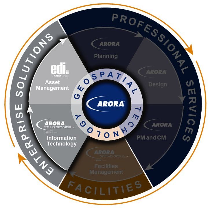
The group is led by our Vice President, Steve Bisch who has over three decades of experience in the design and implementation of enterprise asset management systems (EAM), GIS, software development and facilities maintenance and manufacturing operations management for large organizations.
Mission
The sole mission of Arora’s Enterprise Solutions Group is to provide asset data expertise to guide our clients in generating and leveraging the data created during design and construction for more efficient operations and maintenance and prepare them for the implementation of modern automation technologies such as virtual reality or a Digital Twin. We understand the challenges organizations face to acquire, assimilate, and organize the data required to properly operate and maintain their facilities through accelerated complex design and construction projects, and we have the experience and expertise to help our clients leverage technology to establish world-class operating and maintenance procedures and accelerate their return on investment through our innovative Data Interoperability (DI) process.
Data Interoperability Services
Our approach to DI begins with developing a roadmap unique to each of our clients’ organizations to define standards and processes. These standards ensure the data generated throughout the design and construction process is in the correct format to allow our clients to harness the asset data created on large capital projects. This asset data is often lost in the handover from design and construction teams to owners who rely on that data to operate and maintain these expensive facilities.
Geospatial Data Interoperability
Facilities, buildings, and the assets they contain start their life on drawings and building information models developed by designers and recorded by construction engineers. Arora specializes in extracting this geospatial data and converting it into accurate depictions of exterior and interior space, as well as the location and properties of assets within this space. This geospatial data is the fabric of a digital twin that provides an intuitive interface to all of the relevant information about the space and assets that comprise the facilities we manage. This data also establishes the identify of those assets, or an asset registry, which becomes the hub for interfaces with other enterprise information systems.
 Extracting and transforming this geospatial data and then loading it into asset registry, maintenance management, inspection, Enterprise Resource Planning systems, and digital twins can be a daunting task especially given the variety of standards, not to mention unstandardized data, that typically exists. To overcome this challenge, we leverage tools such as Safe Software’s Feature Manipulation Engine (FME), which is the same technology as Esri’s Data Interoperability Engine and ArcGIS Geoprocessing Tools, as well as industry specific data models and scripts we have developed. We also specialize in establishing data governance, training on the tools we use, and transferring knowledge to our clients so that they can sustain the quality of this data into the future.
Bridging the Gap
Our team works closely with project owners and design and construction teams to establish data, GIS, BIM and handover specification standards to help bridge the gap between the capital project acquisition process and facilities management to ensure our clients’ facilities are ready to go on day one with all the data needed to run a world-class operation – all while saving millions of dollars over the life of the project and the facility compared to the traditional method.
Result
The result is an owner’s dream: a complete, accurate, and structured set of Location and Asset data, plugged into real-time conditions and performance monitoring representing the facility, supported with a navigable 3D model, to be used for managing the operation and maintenance of the facility.