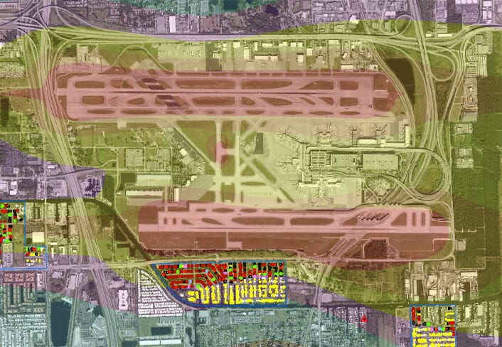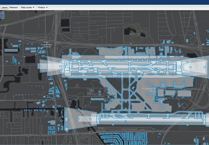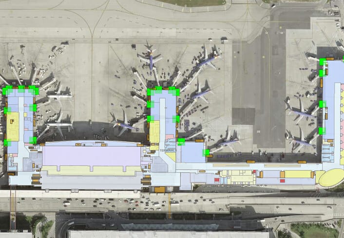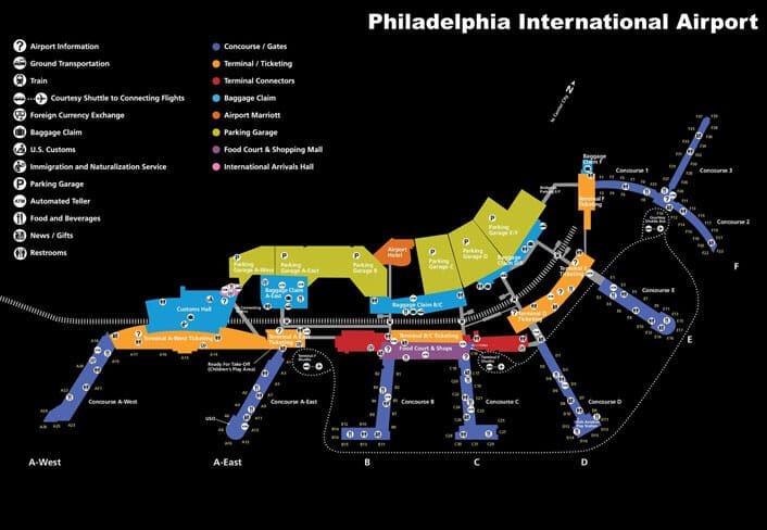
Arora’s Geospatial Practice provides a full range of products and services to help our clients leverage geospatial data and technologies to lower the cost and maximize the effectiveness of their planning, design, operations, and maintenance activities.
From program planning, to architecture design, data collection, application design, and support, our solutions help our clients increase revenue, maintain safety, achieve overall operational efficiency, and comply with regulations. Our team has expertise in BIM/CAD/GIS data development, application configuration, and integration with 3rd party information systems. These capabilities deliver solutions that include lease management, airspace analysis, asset management, utility locating, interior wayfinding, and FAA 18B data compliance.
Our team provides onsite or virtual consulting to assist clients with geospatial program visioning that leverages existing data, IT infrastructure, and data management workflows based on identified goals identified by engaging stakeholders. Recommendations are documented in a Geospatial Roadmap that categorizes tasks by data, systems, and organizational governance.
ArcGIS Indoors Implementation Services
As an approved Esri ArcGIS Indoors Specialty partner, Arora Engineers, LLC (Arora) has the expertise and capacity to quickly transform your indoor floor plans into a digital format that is then used to create configurable map services that fuel web map and mobile solutions that can be distributed via a kiosk, through desktop computers, and/or iOS or Android devices.
The value proposition of implementing ArcGIS Indoors is that you will have the tools, procedures, and publication methods to effectively manage your interior facility data. This data curation and management platform enhances the ArcGIS Enterprise stack which already provides value to your organization.
Our team of seasoned GIS Professionals (GISP) and Analysts are committed to helping you continue to innovate and promote the benefits of geospatial technology to your engineers, planners, facility operators, and executive leadership. We are entering a new age where spatial awareness has become mainstream and the need to integrate siloed applications and workflows has been identified as a necessity with the adoption of Building Information Models (BIM) as a primary design and build deliverable.
The following high-level descriptions provide a snapshot of our technical roadmap to deliver a flexible and sustainable Indoors data curation and maintenance workflow using ArcGIS Indoors.
Arora can also provide onsite or virtual ArcGIS Indoors training for clients that would like to personally take on the data curation and map service creation workflows. This training provides participants with tips we have gleaned through previous data curation projects that are infused into our quality focused production methodology.
 Data Standards – Arora has developed CAD and BIM data standards to migrate data from native formats into the Esri ArcGIS Indoors Information Model (AIIM) format. This includes geometry, annotation, and other related object classes. A review of your CAD and BIM files will be performed, and recommendations provided to significantly streamline the data conversion process.
 Schema Mapping – A crosswalk table is defined which maps CAD layers to AIIM feature classes. Mapping includes details and attributes for the Facility, Levels, and Units (i.e. rooms or spaces). CAD block annotation is mapped to migrate Unit details such as room number, room name, and use type.
 Create Indoors GDB – Using the “Create Indoors Database” geoprocessing tool, the input workspace is defined, and the tool will then generate the ArcGIS Indoors Information Model (AIIM) feature datasets and associated feature classes. In addition, a series of tables are created to assist in configuring the Indoors web and mobile applications.
 Floorplans to Indoors – CAD data is run through the “Floorplan to Indoors” geoprocessing tool which will translate predefined CAD layers into associated AIIM feature classes. Feature classes will be populated with geometry and attributes as defined during the schema mapping task.
 Points of Interest (POI) – POI’s can be generated from a number of methods including data curation from the Units (i.e. rooms) feature class, or from other GIS data collected and managed by your organization. POI’s can include food & beverage concessions, facility services, amenities, fire-life-safety equipment, offices, and numerous other locations of interest. POI’s can be for the general public, support facility operations, and/or emergency management response.
 Wayfinding Network – Automated and semi-automated techniques are used to create the Indoors routing network geometry, either of which will be appended to the Pathways feature class. Transition geometry such as stairs, elevators, and escalators are also curated to provide navigation from floor to floor within your facility. This network is then built and tested using the POI’s previously created to provide step-by-step direction from your location to the selected POI. Once approved this network is published for consumption by subsequent web and mobile applications.
 Configure Web/Mobile Map – Using ArcGIS Pro, an Indoors map view is configured to include the curated feature classes. The Table of Contents (TOC) is established in compliance with Indoors publication requirements and user defined symbology, display field attributes, labeling, pop-ups, and scale dependencies are structured.
 Configuration Tables – Categories and Indoors Configuration tables are populated to define the relationship between the various POI features using user-defined symbol icons, the layering configuration within the TOC of the ArcGIS Pro map, as well as defining key word fields to support application “search” functionality.
 Publish Services for Distribution – Upon completion of the map and table authoring process, the content of the Indoors map view is shared onto the client-side Indoors web portal. Esri has provided an Indoors WebApp template that is used to create and configure the Indoors Web App. Configuration includes linking the routing service (i.e. wayfinding network), setting a scale bar, ability to launch 3rd party applications within the web map, and configuration of a site-specific logo and color scheme based on user defined branding conventions. The web application can then be shared to users in the desktop environment or to the general public in the form of a kiosk application to support wayfinding.
 Mobile Map Package – Using a similar map sharing process from ArcGIS Pro, a Mobile Map Package (MMPK) can also be shared onto the Indoors portal. The Indoors mobile application is available for iOS and Android devices with capabilities for the user to download the mobile application with functionality that mirrors the web application. This provides the user with the same symbology, search, and navigation capabilities on a handheld device.
 Indoors Position System (IPS) – Services can be provided to establish a new IPS through device installation and configuration, or synchronization with Apple’s Core Location service for use on iOS devices. In essence, synchronizing an IPS provides the user with the “blue dot” experience that represents their current location on the device which is superimposed on the Indoors data.
 Quality Assurance – Arora conducts a thorough Quality Assurance (QA) throughout the data conversion processes starting with a comprehensive semi-automated review to ensure data was converted from source to destination as expected, to check for geometry or topology issues, missing or incorrect attributes, and other problems. Once data passes the semi-automated QA, experienced analysts review this data for visual anomalies that do not align with industry standard data quality guidelines or client requirements.
 Data Maintenance Workflows – Arora uses Business Process Model Notation (BPMN) to document current data maintenance business processes and then evaluates this workflow to determine areas where recommended enhancement(s) can be inserted to improve communication, performance, and/or data quality.
 Indoors Training – If interested, Indoors training can be scheduled and conducted onsite or virtually through web collaboration methods. Course curriculum can include basic Indoors 101 data curation and publication exercises or be customized to meet your specific program needs.
The Arora team specializes in implementing ArcGIS Indoors to establish a space management and wayfinding framework. This framework provides a foundation for a variety of web applications that can be deployed on desktop computers or mobile devices to support a wide range of interior space and venue management use cases. Following are some of the more popular use cases:
Operational
- Asset Inventory & Condition Rating
- Facility Inspections
- Emergency Response
- Situational Awareness
- IoT Device Integration
- Work Task Routing Efficiency
Public (Visitors/Passengers)
- Point to Point Wayfinding
- Ability to search for businesses/amenities
- Provide specific business content
- Send Notifications
- Create personalized guest experience
- Augmented Reality Features
Spatial Data Migration
Arora’s philosophy is that value is in the data, but it must be of high-quality, well-structured, and easy to access via intuitive applications to be effective. Our approach is to adapt best-of-breed standards, templates, and processes to your specific data requirements to deliver a baseline of quality data and the means to maintain it going forward. We have refined this approach over the last 20 years working with numerous clients to improve and apply their facility floor plans, exterior base maps, space use data, utility distribution networks, and other CAD/BIM spatial data sources to meet a broad variety of stakeholder needs. Following are the cornerstones of our approach.
 Data Standards – Arora has developed data standards to prepare data for effective migration into an Esri ArcGIS Geodatabase (GDB), as well as Apple’s Indoor Mapping Data Format (IMDF) and ArcGIS Indoors Information Model (AIIM) formats. This includes geometry, attributes, annotation, and metadata.
![]() Data Model – Arora has extensive data modeling experience in a variety of industries ranging from local, county, and state government, to airports, pharmaceuticals to name a few. These models include the Esri’s Local Government Information Model (LGIM), their Utility Network Management, AIIM, Apple’s IMDF, and the Construction Operations Building Information Exchange (COBie) model to name a few. Arora utilizes this experience to develop a data model that will migrate the appropriate geometry and attributes from the input data to the desired destination format.
Data Model – Arora has extensive data modeling experience in a variety of industries ranging from local, county, and state government, to airports, pharmaceuticals to name a few. These models include the Esri’s Local Government Information Model (LGIM), their Utility Network Management, AIIM, Apple’s IMDF, and the Construction Operations Building Information Exchange (COBie) model to name a few. Arora utilizes this experience to develop a data model that will migrate the appropriate geometry and attributes from the input data to the desired destination format.
 Migration Pathways – Arora has developed a variety of data conversion procedures using automated and semi-automated techniques. For efficiency and systematic processing of data, we leverage Extract, Transform, and Load (ETL) software to automatically check, clean, convert, and re-check data as it moves from source (DWG/RVT/IFC) to destination GDB/IMDF/AIIM) format. We prefer Safe Software’s Feature Manipulation Engine (FME), which is the same technology behind Esri’s ArcGIS Data Interoperability Extension for migration. We have used FME for over a decade for numerous clients across the county and are a Safe Software partner with an in-house Certified FME Professional.
 Quality Control – Arora conducts a thorough Quality Assurance (QA) throughout the data conversion processes starting with a comprehensive automated review using our ETL scripts to ensure data was converted from source to destination as expected, to check for geometry or topology issues, missing or incorrect attributes, and other problems. Any failures are quickly caught, so that more laborious and costly steps are avoided. Once data passes automated QA, analysts with experience review this data for visual anomalies aligned with the Federal Geographic Data Committee (FGDC) data quality guidelines.
 Data Maintenance Workflows – Arora uses Business Process Model Notation (BPMN) to document current data maintenance business processes and then evaluates this workflow to determine areas where recommended enhancements can improve communication, performance, and/or data quality.
Key Services
Data Solutions
- Data Development/Maintenance
- Data Governance
- Data Translation/Transformation
- FAA Airports GIS Compliance
- Floor Plan Conversions
- Apple IMDF Creation
- Interior Space Management
- Obstruction Identification
- Signage & Amenity Inventory
- Utility Mapping
System Solutions
- Application Design and Development
- Application Framework Implementation
- CAD / GIS / BIM Interoperability
- Cloud Hosted Solutions
- Enterprise System Design, Implementation, Support
- Legacy System Integration
- Software as a Service (SaaS) Solutions
- Venue Management Platform
Organizational Solutions
- Cost / Benefit Studies
- Governance Models
- Implementation and Strategic Plans
- Needs Assessments
- Staff Augmentation
- Staffing Plans
- Technology Road Maps
- Vendor Evaluation Services
Research and Studies
- Airports Cooperative Research Program (ACRP)
- Airport Master Plan Updates
- Airport Layout Plans (ALP)
- Airspace Analysis (Obstruction Surveys / Evaluations)
- Inventory and Existing Airport Conditions
- Obstacle Action Plans (OAP)
- Obstruction Analysis
- Airport System Planning
- Environmental and Noise Studies
- National Cooperative Highway Research Program (NCHRP)
Representative Clients
- Boston Logan International Airport
- Cincinnati / Northern Kentucky International Airport
- Columbus International Airport
- Dallas / Fort Worth International Airport
- Fort Lauderdale-Hollywood International Airport
- Hartsfield-Jackson Atlanta International Airport
- John Wayne Airport
- Minneapolis–Saint Paul International Airport
- Myrtle Beach International Airport
- Philadelphia International Airport
- Reno-Tahoe International Airport
- San Diego International Airport
Representative Spatial Data Migration Clients
- Massachusetts Port Authority
- Philadelphia International Airport
- Minneapolis St. Paul Airport
- Baltimore Washington International Airport
- Fort Lauderdale-Hollywood International Airport
- Hartsfield-Jackson Atlanta International Airport
- Cincinnati/Northern Kentucky International Airport
- John Glenn Columbus International Airport


