News | Nov 19, 2025 | Anne Keener
From Data to Discovery: Celebrating GIS Day 2025
At Arora Engineers, our Geospatial Team is redefining how organizations visualize, manage, and act on their data. This GIS Day, we’re celebrating the technology and talent that connect people, places, and purpose, transforming complex information into actionable insights that enhance safety, efficiency, and sustainability across industries.
Aviation: Building Bridges Between Teams
At Philadelphia International Airport (PHL), every department speaks a different language, engineering in systems, operations in uptime, finance in budgets, and sustainability in efficiency. Through collaboration with PHL, Arora’s Geospatial Team developed the Gate Tool, a GIS-powered platform that brings those conversations together in one shared map.
With just a few clicks, airport staff can view the condition of passenger boarding bridges, PC Air units, and other assets in real time. This single source of truth connects every stakeholder, from planners to technicians around the same visual data.
Like the boarding bridges on the ramp, GIS helps everyone meet in the middle, turning information into insight and teamwork into tangible results.
Water Predictive Modeling for Safer Communities
GIS isn’t just about mapping what we can see, it’s about uncovering what we can’t. In the “Get the Lead Out” initiative, Arora’s Geospatial Team used predictive modeling and machine learning to identify where lead service lines are most likely to exist, without digging up a single yard.
By analyzing neighborhood data, housing age, and installation records, GIS helps pinpoint high-risk areas and prioritize field inspections. This data-driven approach empowers utilities and municipalities to protect public health more efficiently and cost-effectively.
It’s a smarter, faster, and safer way to make our communities healthier.
Facilities & Public Safety: Pre-Incident Planning for Readiness
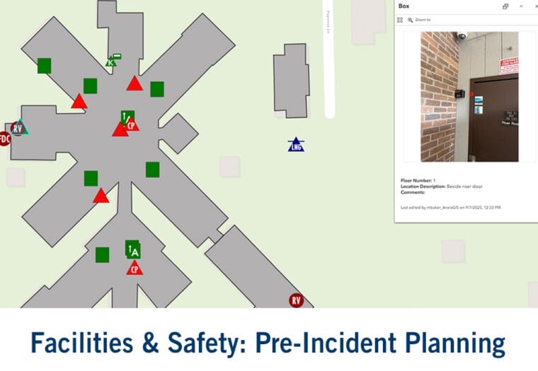
When seconds matter, information saves lives. Arora’s GIS-based Pre-Incident Planning solution helps fire departments and safety agencies prepare before an emergency even begins.
By digitizing site data, floor plans, and hazard information, the solution enables first responders to assess risks, plan access routes, and understand building layouts, all in one centralized map.
The result: faster coordination, safer crews, and stronger protection for people, property, and the environment. It’s GIS at its most powerful, turning preparation into prevention.
Mapping the Future
From airports to utilities to public safety agencies, GIS technology is redefining how organizations see, share, and act on their data.
At Arora Engineers, we believe GIS is more than a tool, it’s a bridge between disciplines, helping teams work smarter, collaborate faster, and build a safer, more connected world.
This GIS Day, we celebrate the innovators who transform data into decisions, and the maps that help us all find common ground.
Visit our Geospatial Services page to explore how Arora Engineers is advancing digital transformation through GIS and smart infrastructure.


