PAE GIS Services and Data Management System Implementation
Arora Engineers (Arora) provided Prime GIS services to Snohomish County, Washington for the development of its GIS Program at Paine Field Airport (PAE). The Arora team completed a strategic plan for an integrated data management solution for the airport. As a result of this plan, Arora provided services that included several aspects of data management and application development.
SCOPE OF SERVICES INCLUDED:
- Developed airport data standards for Geographic Information Systems (GIS) and Computer-Aided Design (CAD) in collaboration with the county
- Established airport file structure and storage protocols in collaboration with the County as part of the airport data assessment analysis
- Configured OpenText documents to GIS features accessed by PAE’s GIS Portal applications
- Established Geospatial Data Governance Program report (foundation for overall County expansion)
- Developed a series of Master Computer-Aided Design (mCAD) files for PAE
- Configured FME workspaces (FMW) to convert CAD to Esri feature classes
- Designed and populated a Master Geodatabase (mGDB) for PAE
- Created GIS applications on PAE’s ArcGIS Enterprise Portal
- Designed and developed an ArcGIS Sites web page to access PAE’s GIS Portal applications
GIS and CAD Data Standards
For the development of the GIS and CAD standards, best industry practices and Arora’s experience were applied to align with and extend beyond the FAA’s AGIS schema definition and mapping requirements for specific GIS feature classes, such as utilities and floor plans. The data standards included the development of a crosswalk between CAD and GIS feature classes, documentation of projection, topology, objects, drawing components, accuracy, metadata, maintenance, and the development of data submission and quality assurance recommendations.
File Structure / Storage Protocols and OpenText/SharePoint Files
In collaboration with the County, as part of the airport data assessment analysis to review and define the content and extent of geospatial information, recommendations on file naming, hierarchy, and storage procedures were documented in a data assessment report. A list of files to be consolidated and converted to GIS and linked to GIS feature classes were also developed. SharePoint was used to upload and store various versions of project files (30/60/90% design documents), while OpenText, with the addition of search tags, was used to upload and store the final version of project documents, such as lease agreement and environmental project documentation linked to GIS data/applications.
Geospatial Data Governance
Leveraging industry research and prior knowledge of airport best practices, Arora provided a framework and foundation for the County’s geospatial data governance program. The County expanded upon its established committees to set priorities and define roles and responsibilities that encompassed:
- Creation of geospatial data governance technical and steering committees
- Defined goals, objectives, and key performance metrics (KPIs)
- Preparation of a communication plan
- Written – reporting and meeting documents, verbal – conference calls training, electronic – GIS Portal page/data sharing
- Development of a risk management plan (risk matrix, monitor, response)
- Development of a data change management
- Draft data management standardization / operational adaptation routines, document current project data workflow and recommend enhancements, training
- Development of policies and procedures
- Data submission requirements, data development and maintenance procedures, system/architecture, data/system security, geospatial data standards
Master CAD files and FME Workspaces (FMW)
Arora collected and used CAD files discovered during data assessment to develop a series of master (mCAD) drawing files to capture information related to PAE’s floor plans; the utilities of communication, electrical, fuel, wastewater, water and stormwater; and properties via Exhibit A. Arora modified layers and object structure to meet the documented CAD data standards, adjusted topology of CAD objects to create a seamless network, created meta properties in the final DWG files, performed quality control during the data development, and identified and addressed data anomalies encountered.
Next, Arora developed FMWs configured and designed to convert specified CAD geometry and objects created into GIS feature classes for loading into the mGDB developed for PAE. Training materials were prepared, and a one-day training was provided to the County/PAE staff to locally deploy and run FMWs on county-owned and maintained FME software. Technical phone/remote support was also provided for the remainder of the contract.
Master Geodatabase and Web-based GIS Applications
A master geodatabase mGDB based on the GIS data standard was developed and populated via the FMWs, existing airport GIS files, and master plan consultant 18B data, including pavement assessment data. Quality control was performed on the feature classes by the FMWs to confirm that applicable geometry and attributes converted as intended. In addition, the quality assurance / quality control (QA/QC) procedures were documented.
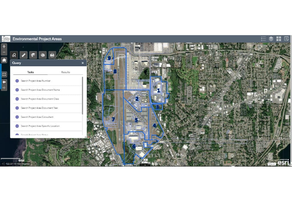
Arora developed, deployed, and documented use case functional and data requirements for the review and approval of configured web-based applications. Residing on the County’s Esri Residing on the County’s Esri ArcGIS Enterprise (Portal), applications and/or ArcGIS Online, applications developed from the master plan data include several viewers including general airport data / assets, environmental project areas and Exhibit A lease areas with documents linked on OpenText, floor plan spaces, pavement inventory, and utilities viewers including communication, electrical, fuel, storm water, drainage inventory, wastewater, water, and utility shutoff locations. Application user documentation and training and support were also provided.
PAE ArcGIS Sites Web Page to access the Portal GIS Applications
Arora developed an ArcGIS Sites web page for airport staff to easily access all the airport’s GIS applications developed on the County’s Portal infrastructure. Data area sites were developed to view specific data areas including Airfield, Environment, Facilities/Floor Plans, Pavement, Properties, and Utilities. The Sites web page can be easily revised to add additional data areas, GIS application links, and airport information.


